VietnamWayfarerEST. 2026
目的地旅程食べ物 & 飲み物旅行のヒント
ニュースレター →
Browse by region▲Bắc · Northern■Trung · Central●Nam · Southern
+Travel essentialsISSUE №01 · MMXXVIAbout
Vietnam
Wayfarer.
Colophon

An independent field guide to Vietnam — food, destinations, and the kind of practical advice you only get from people who live here.

Get the dispatch

Monthly: dishes, destinations, itineraries — once a month, straight to your inbox.

Subscribe →
Topics
  • 目的地
  • 食べ物 & 飲み物
  • 旅程
  • 旅行のヒント
Regions
  • Northern Vietnam
  • Central Vietnam
  • Southern Vietnam
Resources
  • About
  • Contact
  • Affiliate Disclosure
  • Disclaimer
  • Privacy
  • Terms
© 2026 Vietnam WayfarerMade in VietnamAll rights reserved
Independent · Reader-supported

We use minimal analytics + ads (no personal tracking). See our privacy policy.

Binh Thuan省:ビーチ、Cham文化、そして海岸の風景 | Vietnam Wayfarer
  1. Home
  2. Destinations
  3. Binh Thuan省:ビーチ、Cham文化、そして海岸の風景
🇯🇵 Destinations · south · phan-thiet

Binh Thuan省:ビーチ、Cham文化、そして海岸の風景

乾燥した気候、北西部の山岳地帯、豊かな漁場、そして独特のChamコミュニティで知られるベトナム中南部の沿岸省。観光客の主な玄関口はPhan ThietとMui Neです。

By the Wayfarer teamApr 4, 20265 min read
Bình Thuận province
↑ Bình Thuận provinceImage via Wikipedia (Bình Thuận province, CC BY-SA)
Tags
#binh thuan#phan thiet#mui ne#phu quy island#cham culture#south central coast#beach provinces#vietnam history
You might also like
Motorbikes and vendors at Phan Ri Cua Market, flourishing with activity.
Destinations

What to Eat in Binh Thuan: A Traveler's Guide to Local Dishes and Markets

May 24, 20266 min
Delicious Bánh Căn Vietnamese rice pancakes garnished with scallions and crispy shallots.
Food & Drink

Banh Xeo: Vietnam's Sizzling Pancake, Region by Region

Mar 11, 20264 min
— FIN —

Last updated · May 19, 2026 · independently researched, never sponsored.

More like this
→

Keep reading — related guides.

All destinations →

More from Southern Vietnam

Other articles covering the same region.

Traditional Chinese ancestral shrine with ornate wooden panels and calligraphy.
Destinations

Van Thanh Mieu Vinh Long: A Traveler's Guide to the Mekong Delta's Confucian Temple

Van Thanh Mieu in Vinh Long is one of the best-preserved Confucian temples in southern Vietnam — here's how to visit, what to see, and where to eat nearby.

May 25, 20266 min read
A vibrant scene of a street food vendor at Đà Lạt Night Market, Vietnam.
Destinations

Comments

Loading…

コメントを残す

メールはGravatarアバターと返信通知用です。公開されません。

月刊ディスパッチ

ベトナム旅行のご予定は?
もっと賢く食べて旅しよう。

月に1回:新しい料理、知る人ぞ知る目的地、旅程 — メールでお届け。スパムなし、いつでも配信停止可能。

1,247名の読者 · 第一号:2026年6月
01 · Itineraries
2 Weeks in Vietnam: The Perfect First-Timer's Itinerary
16 min read
  • 02 · Food & Drink
    Pho in Hanoi: The 7 Bowls That Are Actually Worth Lining Up For
    11 min read
  • 03 · Destinations
    The Ha Giang Loop: A Complete 4-Day Motorbike Adventure Guide
    14 min read
  • Phu Quoc Night Market: A Traveler's Guide

    Everything you need to know about Phu Quoc Night Market — from the best seafood stalls to navigating the crowds and avoiding tourist traps.

    May 25, 20265 min read
    A woman skillfully peels a pineapple at a bustling night market in Hanoi, Vietnam, showcasing urban life.
    Destinations

    What to Eat in Dong Nai: Local Dishes, Markets & Where Locals Go

    Dong Nai's food scene sits between industrial city grind and rural delta freshness. Here's where to find the real food—markets, family-run joints, and dishes that rarely make it to guidebooks.

    May 25, 20265 min read

    More in Destinations

    More articles from the same category.

    View all in Destinations →
    Scenic aerial view of Bac Son Valley, Vietnam, capturing houses and lush fields at sunset.
    Destinations

    Dinh Phat Chi (Lang Son): A Traveler's Guide

    Dinh Phat Chi is one of Lang Son's highest peaks and a rewarding day trek near the Chinese border. Here's everything you need to plan the trip.

    May 25, 20267 min read
    Breathtaking view of a Buddhist temple amidst stunning limestone mountains in Ninh Bình.
    Destinations

    Chua Ham Long in Bac Ninh: A Traveler's Guide

    Chua Ham Long is a centuries-old Buddhist pagoda tucked into a limestone hillside near Bac Ninh. Here's what to expect and how to visit.

    May 25, 20266 min read
    A peaceful motorcycle ride on the winding roads of Van Ho amidst lush mountains.
    Destinations

    How to Get to Ninh Thuan: Transport Options from Hanoi, Saigon & Da Nang

    Ninh Thuan sits on Vietnam's south-central coast, halfway between Da Nang and Ho Chi Minh City. Here's how to reach it by bus, train, flight, or motorbike—plus costs and realistic travel times.

    May 25, 20265 min read
    A lone explorer illuminates a vast, mysterious cave in Son La, Vietnam with a torch, showcasing nature's hidden wonders.
    Destinations

    Nang To Thi in Lang Son: A Traveler's Guide to Vietnam's Most Famous Rock Formation

    Nang To Thi is a limestone rock formation in Lang Son that's woven into Vietnamese folklore. Here's what to expect, how to get there, and what to eat nearby.

    May 25, 20266 min read
    The Center of Vietnam Quintessential Handicraft showcases modern architectural design with wave-like patterns.
    Destinations

    Vietnam Fine Arts Museum in Hanoi: A Traveler's Guide

    Everything you need to know before visiting the Vietnam Fine Arts Museum in Hanoi — what to see, how to get there, and what to eat nearby.

    May 25, 20266 min read
    Vibrant green guest house surrounded by lush greenery and a serene road setting.
    Destinations

    Where to Stay in Lam Dong: Budget to Luxury by Neighborhood

    Lam Dong's main towns offer distinct vibes for different travelers. Here's how to pick a base—from Da Lat's colonial guesthouses to Thac Dac's jungle ecolodges.

    May 25, 20264 min read
    View all in Destinations →
    Hidden gems

    Lesser-known articles tourists usually miss

    • 01
      food

      Banh da lon: Vietnam's Colorful Layered Steamed Cake

    • 02
      food

      Best Bun Ca in Nha Trang: Where Locals Send You

    • 03
      food

      Best Ham Bao in Phu Quoc: Where Locals Send You

    ← Older
    Ca phe muoi: Vietnam's salt coffee, where it came from and why it works
    Newer →
    Tra Vinh: Mekong Delta province with deep Khmer roots

    Binh Thuanは、ベトナム(베트남 / 越南 / ベトナム)の中南部沿岸地域に位置する沿岸省であり、北はLam Dongとの高原の境界から南シナ海まで広がっています。地理と歴史によって形作られたこの地は、内陸部の山々、島々が点在する平坦な海岸線、そして何世紀にもわたるCham、Kinh、および少数民族の定住を反映した人口構成を特徴としています。

    地理と気候

    この省の地形は、北西部の山岳地帯(Lam Dongと接する)と平坦な沿岸平野の2つのゾーンに分かれています。最高峰は標高1,548メートルで、Lam Dongの境界に近いTanh Linh郡に位置しています。海岸線には標高200メートルを超える小さな丘が点在し、沖合にはいくつかの島があります。Phan Thietの南東約120キロメートルに位置するPhu Quy島(独立した郡)、東部のCau島、Mui Ne(무이네 / 美奈 / ムイネー)近くのLao島、そして西部のBa島です。

    Binh Thuanは、ベトナムで最も乾燥した省の一つです。省内の大部分で年間降水量は800 mm未満であり、乾季(11月〜4月)の降水量は200 mmを下回ります。この乾燥した気候が風景を決定づけています。2007年時点で、森林は省の50%(394,100ヘクタール)を覆い、北および北東の山岳地帯に集中している一方、農地は284,200ヘクタールを占め、これは中南部沿岸のすべての省の中で最大の数字です。

    主要な河川には、東部のLui川、中央部のCai川、西部のDinh川があり、そのほとんどが東に向かって海へと流れています。内陸部には、Phan Thietの北約30キロメートルにSong Quan湖があります。

    歴史的ルーツ:Chamとベトナムの統合

    現在のBinh Thuanの大部分は、歴史的にChamの公国であるPandurangaの一部でした。Chamの人々は何世紀にもわたって沿岸の村々に住んでいましたが、ベトナムの拡大により徐々にこの地域は統合されていきました。1832年までに、Ninh ThuanとBinh Thuanは完全にベトナムに統合されました。

    20世紀には行政境界が何度か変更されました。1976年以前、Binh Thuanは現在よりも小さく、西部地域は独立したBinh Tuy省を形成していました。1976年に、Binh Tuy、Binh Thuan、Ninh Thuanが合併してThuan Hai省となりました。1991年にこれは再びNinh ThuanとBinh Thuanに分割され、Binh TuyはBinh Thuanに再編入されました。

    民族の多様性

    Kinh(ベトナムの主要民族)が多数派を占めていますが、Binh Thuanの民族構成はその歴史を反映しています。Chamのコミュニティは東部の沿岸地域に住んでおり、Tuy Phong郡のCawait(Lac Tri)やHam Tan郡のBhumi(Lang Cham)といったChamの名称を持つ独自の村を維持しています。その他の少数民族であるKohoやRaglaiの人々は、Lam Dongとの境界沿いの山岳地帯に居住しています。Hoa(中国系)もまた、重要な少数民族を構成しています。

    背景に風力タービンが見える晴れたビーチで、ボードを抱えて微笑むカイトサーファー。

    Photo by Serg Alesenko on Pexels

    経済と資源

    2007年時点で、Binh Thuanの経済は中南部沿岸地域で最も急成長しており、年平均成長率は約14%でした。1人当たりのGDPは1,100万VNDで、Da NangとKhanh Hoaに次いで同地域で3位でした。

    農業と漁業: 主要な作物は米であり、2007年の収穫量は434,600トン(2000年の321,500トンから増加)でしたが、米が占める農地は約3分の1に過ぎません。この省では、ゴム、コショウ、カシューナッツの栽培を拡大しています。沿岸部とPhu Quy島は、エビ、イカ、マグロの豊かな漁場を提供していますが、漁業が省の経済に占める割合は農業よりも低くなっています。

    工業: 産業部門は2007年まで年率21.6%で成長し、主に民間企業や外資系企業によって牽引されました。国有産業は衰退しました。開発は、西海岸沿いのチタン埋蔵地との土地の権利の重複という課題に直面しました。

    また、この省は北西部の山岳地帯にヒ素の埋蔵量も有しています。

    人口と都市化

    2007年のBinh Thuanの人口は1,170,700人で、年率1.35%(2000〜2007年)で増加しました。都市部は年率4.42%とより速いペースで拡大し、都市化率は30.4%(2000年)から37.5%(2007年)に上昇しました。これは中南部沿岸の省の中でKhanh Hoaに次いで2番目に高い数字です。人口密度には大きなばらつきがあり、Phan Thietでは1平方キロメートルあたり約1,000人ですが、Bac Binh、Ham Tan、Tanh Linhなどの郡では100人未満でした。
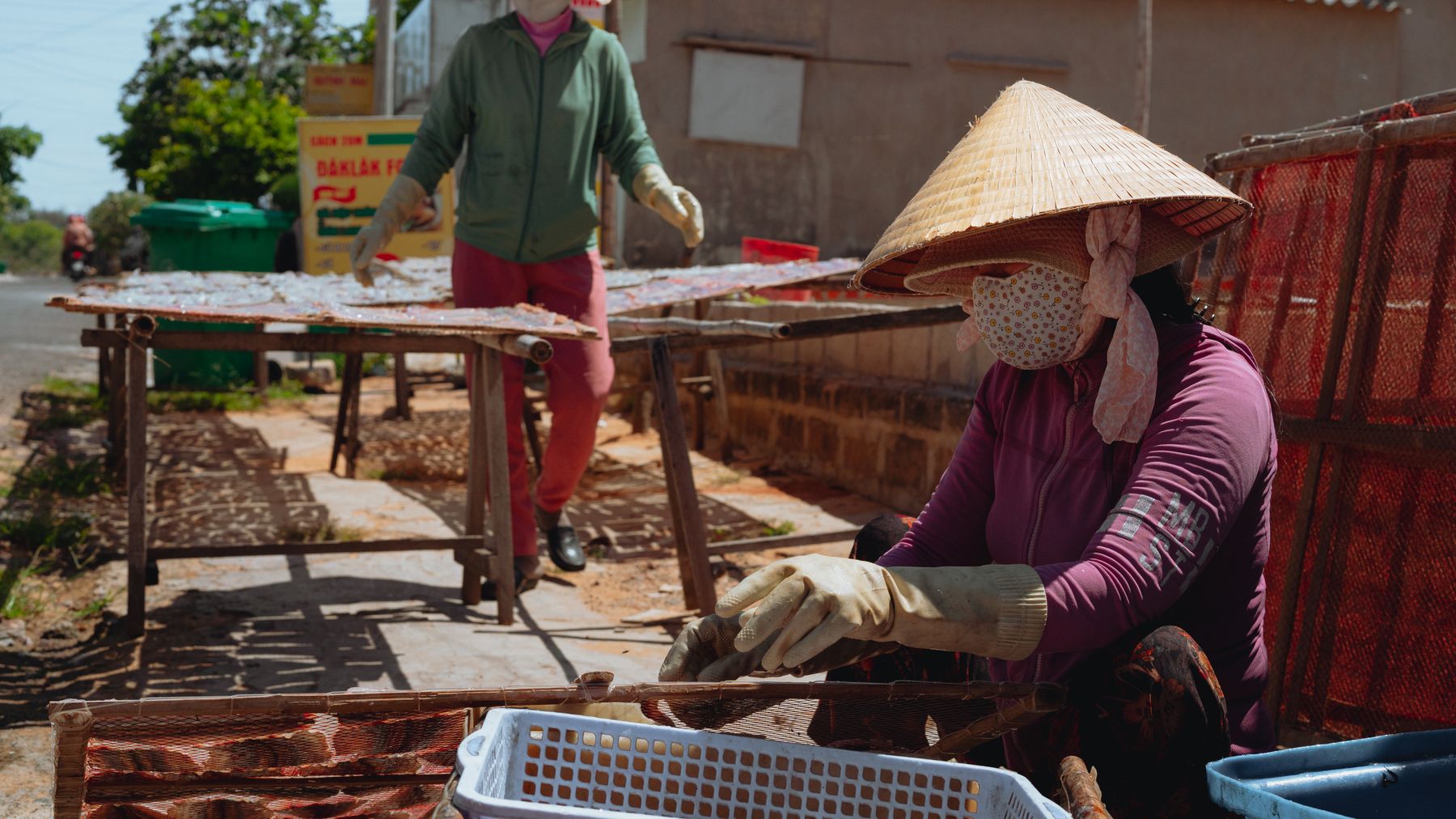
    Binh Thuanで太陽の下で海産物を乾燥させる労働者たち。伝統的な手法と農村の生活を示している。

    Photo by Theodore Nguyen on Pexels

    主要な町と郡

    省都であるPhan Thietは、観光客にとっての主要な玄関口です。この省は行政的に8つの郡(Bac Binh、Duc Linh、Ham Thuan Bac、Ham Thuan Nam、Ham Tan、Phu Quy、Tanh Linh、Tuy Phong)、1つの郡レベルの町(La Gi)、および多数のコミューンと区に分割されていました。沖合に位置するPhu Quy島は独自の郡を構成しており、賑やかな本土の海岸に比べて静かな島での体験を提供しています。

    観光客向け情報

    Binh Thuanの魅力は、そのビーチ(特にMui NeとPhan Thiet)、島での休暇、そして高地にあるChamの文化遺産や少数民族の村へのアクセスにあります。乾燥した気候のため、1年の大半が晴天で乾燥しており、ビーチで過ごすのに最適です。ただし、乾季(11月〜4月)が観光のピークとなります。省の急速な経済成長によりインフラや宿泊施設が拡充されましたが、内陸部の大部分は海岸部に比べてまだ開発が進んでいません。

    よくある質問

    Binh Thuan省はどこにあり、どのような風景ですか?

    Binh Thuanはベトナムの中南部沿岸に位置し、北西はLam Dong省、東は南シナ海に接しています。地形は2つのゾーンに分かれています。Tanh Linh郡にある標高1,548メートルの山頂を持つ北西部の山岳地帯と、島々が点在する平坦な沿岸平野です。沖合には、Phan Thietの南東約120キロメートルに位置するPhu Quy島のほか、Cau島、Lao島、Ba島があります。

    Binh Thuan省には歴史的にどのような民族が住んでいましたか?

    Kinh(ベトナムの主要民族)が多数派を占めていますが、東部ではChamのコミュニティが独自の沿岸の村を維持しています。これにはTuy Phong郡のCawait(Lac Tri)やHam Tan郡のBhumi(Lang Cham)が含まれます。KohoやRaglaiの人々はLam Dongとの境界沿いの山岳地帯に住んでおり、Hoa(中国系)もまた重要な少数民族です。この地域は1832年にベトナムに完全に統合されるまで、Chamの公国であるPandurangaの一部でした。

    Binh Thuanの乾季はいつで、どのくらい乾燥しますか?

    乾季は11月から4月まで続き、この期間、省内の大部分で降水量が200 mmを下回ります。Binh Thuanは全体としてベトナムで最も乾燥した省の一つであり、ほとんどの地域で年間降水量が800 mm未満です。この乾燥した気候が風景を大きく形作っています。2007年時点で、森林は省の50%(394,100ヘクタール)を覆い、降水量の多い北および北東の山岳地帯に集中していました。