Cong Troi Quan Ba sits at roughly 1,500 meters above sea level on the road between Ha Giang city and Dong Van. It's the first major mountain pass on what most travelers know as the Ha Giang Loop, and it earns its nickname — Heaven's Gate — honestly: on a clear morning, you're looking out over a valley floor scattered with limestone karst towers and terraced rice paddies that drop away beneath you like a green staircase.
What it is
Cong Troi Quan Ba is a mountain pass and viewpoint in Quan Ba district, in the far north of Vietnam (베트남 / 越南 / ベトナム). Administratively, this area now falls under Tuyen Quang province following a regional merger, though most travel resources still reference Ha Giang — and that's the name you'll see on bus tickets and booking sites for the foreseeable future.
The pass marks the boundary where the Viet Bac hills give way to the Dong Van Karst Plateau, a UNESCO Global Geopark. Below the viewpoint, you can see the "Nui Doi" — the Twin Mountains, also called Fairy Bosom Mountains — two almost perfectly symmetrical hills rising from flat paddy fields. Local Hmong legend says a fairy created them to nurse her child. Geologists will tell you they're limestone remnants shaped by erosion. Either explanation is worth the drive.
Why travelers go
Most people hit Cong Troi Quan Ba as the first major stop on a 3-4 day Ha Giang (하장 / 河江 / ハーザン) Loop. It's the moment the road gets serious — the terrain shifts, the valleys deepen, and you realize you've left the lowlands behind. But it's also worth visiting even if you're not doing the full loop. The viewpoint is accessible by car or motorbike from Ha Giang city in under two hours, making it a viable day trip.
The draw is simple: the view. No ropes course, no ticket booth theme park. Just a concrete platform, a few local vendors selling roasted corn and sugarcane juice, and a panorama that reminds you why you came north.
Best time to visit
The sweet spot is September through November, when rice terraces below the pass turn gold before harvest. Mornings tend to be clearest — cloud cover rolls in most afternoons, especially from June through August during rainy season.
March through May is the second-best window. The terraces are bright green with young rice, and wildflowers — including buckwheat if you catch late October into November — color the roadsides. December through February is cold and often foggy at this altitude. You might see nothing from the viewpoint, and the road can be slippery. If you go in winter, leave Ha Giang city early and hope for a clear patch before noon.
How to get there
From Hanoi, take a sleeper bus to Ha Giang city. Several operators run overnight departures from My Dinh bus station — expect to pay 250,000-350,000 VND one way, arriving after about six hours. From Ha Giang city, Cong Troi Quan Ba is approximately 46 km north along QL4C, which takes around 1.5-2 hours by motorbike depending on your comfort with mountain switchbacks.
You have three main transport options from Ha Giang city:
- Rent a motorbike: 150,000-200,000 VND per day for a semi-automatic (Honda Wave or Blade). This is how most backpackers do the loop.
- Hire an easy rider: A local driver who takes you on the back of their bike. Around 600,000-800,000 VND per day including the bike and fuel.
- Private car or jeep: If you'd rather not ride, local tour operators arrange cars with drivers for roughly 1,500,000-2,000,000 VND per day. Less wind in your face, more legroom.
There's no public bus that stops conveniently at the viewpoint itself.

Photo by Du Tử Mộng on Pexels
What to do
Stand at the viewpoint platform
Obvious, but don't rush it. The main platform has a small parking area and a few drink stalls. Walk past the souvenir stands to the left edge for a less crowded angle. Early morning — around 7:00-8:00 AM — gives you the best light and thinnest crowds.
Walk down toward the Twin Mountains
From the pass, the road descends into Quan Ba town. About 3 km downhill, a dirt path leads closer to the base of Nui Doi. It's a 20-minute walk through rice paddies. No signage — ask at any house along the road and someone will point you the right way.
Visit Quan Ba town market
Quan Ba town sits in the valley below the pass. Its Sunday morning market draws Hmong, Dao, and Tay families from surrounding villages. It's a working market, not a tourist setup — expect livestock, tobacco, fabric, and local produce. Get there before 9:00 AM for the full atmosphere.
Hike to Nam Dam village
About 8 km from Quan Ba town, Nam Dam is a Dao community that has organized a low-key homestay program. The walk takes around two hours on a dirt road through terraced fields. You can arrange a guide through your homestay in Quan Ba for around 200,000-300,000 VND.
Stop at the Hmong King's Palace in Sa Phin
If you're continuing north on the loop, the palace of Vuong Chinh Duc — a Hmong clan leader from the early 1900s — is about 50 km past Quan Ba in Sa Phin. It's a French-Chinese hybrid mansion built with opium money, now preserved as a historical site. Entry is 20,000 VND.
Where to eat nearby
Quan Ba town has a handful of "com pho" shops — basic rice-and-noodle joints along the main road. Look for "thang co", a Hmong offal and horse meat hotpot simmered for hours with cardamom and ginger. It's an acquired taste and genuinely interesting if you're open to it. A bowl runs about 30,000-40,000 VND.
For something more familiar, most roadside places serve "pho" or a plate of "com tam" with grilled pork. Don't expect menus — point at what other diners are eating. A full meal with a beer rarely exceeds 80,000 VND.
Where to stay
Quan Ba town has homestays and a few basic guesthouses. Expect 150,000-300,000 VND per night for a homestay with a mattress on the floor, shared bathroom, and dinner included. A couple of newer guesthouses offer private rooms with hot water for 400,000-500,000 VND.
Most loop riders push on to Yen Minh or Dong Van for the night, which means Quan Ba stays are quieter and less booked up. If you want a slower pace, spending a night here instead of racing through is a good call.
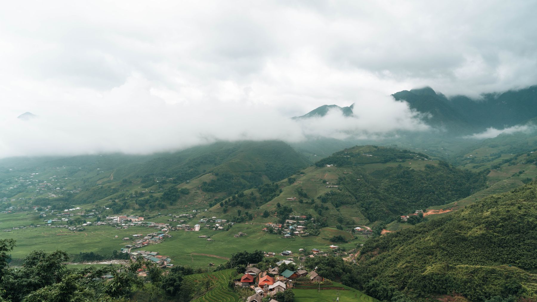
Photo by Quang Vuong on Pexels
Practical tips locals would tell you
- Fuel up in Ha Giang city. There's a gas station in Quan Ba town, but it sometimes runs dry on busy weekends.
- Bring a light jacket even in summer. At 1,500 meters, mornings at the pass are noticeably cooler than Ha Giang city.
- Carry cash. No ATMs in Quan Ba town as of early 2025. The last reliable ATM is in Ha Giang city.
- If you're riding a motorbike, honk before every blind curve. Trucks and buses use the full road.
Common mistakes to avoid
- Arriving midday: The light is flat, the viewpoint is crowded with tour groups, and clouds often block the valley. Aim for early morning.
- Skipping Quan Ba entirely: Many loop riders blast through on day one to reach Dong Van by dark. If you started early from Ha Giang, you have time to stop for an hour without wrecking your schedule.
- Wearing sandals on the viewpoint walk: The steps and surrounding paths get slippery after rain. Closed shoes save you trouble.
- Not checking your bike before the pass: QL4C north of Ha Giang city is where the road gets steep. Brakes, tires, and chain tension matter more from this point on.
Practical notes
Cong Troi Quan Ba works as a day trip from Ha Giang city or as the natural first stop on a multi-day Ha Giang Loop. Budget at least 90 minutes at the pass itself — longer if you walk down toward the Twin Mountains. The area is worth its reputation as an opening act for the karst plateau ahead.
Last updated · May 29, 2026 · independently researched, never sponsored.





