Mui Ca Mau National Park sits at the geographic bottom of Vietnam, where the Mekong Delta (메콩 델타 / 湄公河三角洲 / メコンデルタ) finally runs out of land and spills into open sea. It's not a place you stumble into — getting here takes effort — but for travelers who want to see the delta at its rawest, there's nothing else like it.
What it is
The park covers roughly 41,800 hectares of mangrove forest, mudflats, and coastal wetland at the very tip of Ca Mau province. It was designated a national park in 2003 and later recognized as a UNESCO Biosphere Reserve. The landscape is dominated by "dung" (mangrove apple) and "mam" (avicennia) mangrove species, and the coastline here is one of the few places in Vietnam (베트남 / 越南 / ベトナム) where you can watch land actively forming — sediment from the Mekong system deposits new ground at a rate of roughly 50-80 meters per year on the western coast.
The park's centerpiece is the Dat Mui (Cape Ca Mau) landmark, a concrete marker at GPS coordinates 8°37'N that represents the southernmost point of mainland Vietnam. It's one of those places that feels more significant when you're standing there than it probably should — wind off the Gulf of Thailand, mangroves behind you, muddy water stretching to the horizon.
Why travelers go
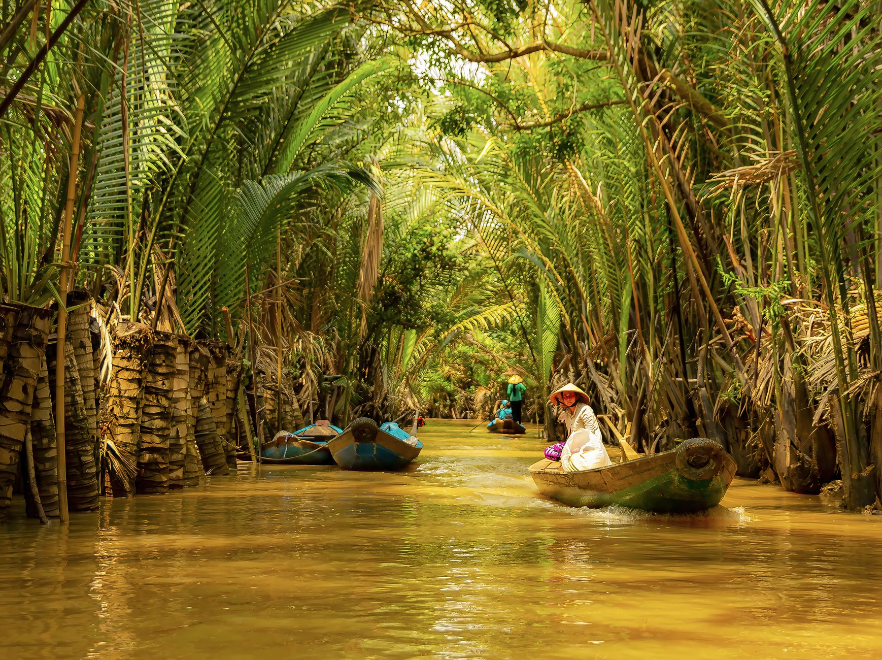
Most Vietnamese visitors come for the symbolic weight — standing at the country's southern tip, the way northerners make pilgrimages to Lung Cu in Ha Giang at the northern extreme. For international travelers, the draw is different: this is deep Mekong Delta without the tourist infrastructure of Can Tho or the day-trip crowds from Saigon. The mangrove forests here are genuinely wild. Birdwatchers come for the resident populations of herons, cormorants, and migratory shorebirds. And the boat journeys through narrow mangrove canals have a quiet intensity that the busier floating markets up-river can't match.
Best time to visit
The dry season from December through April is the practical window. Rain tapers off by late November, and from December to February the weather is comfortable — less humidity, temperatures around 26-30°C, and calmer seas for the boat trip. March and April get hotter but remain dry.
Avoid June through October if you can. The wet season turns trails to mud, cancels some boat routes, and the mosquitoes become genuinely aggressive. November is transitional — sometimes fine, sometimes not.
Birdwatching peaks between December and March when migratory species are present.

Photo by maxed. RAW on Pexels
How to get there
Ca Mau city is your staging point. From Saigon, you have a few options:
- Bus: Phuong Trang (FUTA) and Thanh Buoi run sleeper buses from Saigon's Mien Tay bus station to Ca Mau city. The trip takes about 8-9 hours and costs 200,000-280,000 VND. Overnight departures save you a hotel night.
- Flight: Vietnam Airlines and Bamboo Airways operate flights from Tan Son Nhat to Ca Mau airport (about 1 hour). Fares range from 800,000-1,500,000 VND booked in advance.
- From Can Tho: Buses from Can Tho to Ca Mau take roughly 3.5-4 hours, around 120,000-160,000 VND.
From Ca Mau city to the national park, you need to get to the Nam Can or Dat Mui pier (roughly 100 km south). You can hire a motorbike for the ride to the pier — the road is paved and passable — or arrange a car through your hotel (expect 800,000-1,200,000 VND round trip). From the pier, a speedboat into the park and to the cape takes about 25-35 minutes. Boat tickets run around 100,000-150,000 VND per person for shared boats, or you can charter one for 600,000-900,000 VND.
What to do
Walk the mangrove boardwalk
A raised wooden boardwalk extends through the mangrove canopy near the Dat Mui area. It's roughly 1.5 km long and puts you at eye level with the root systems and the crabs, mudskippers, and monitor lizards that live among them. Early morning is best — fewer people, cooler air, more wildlife activity.
Boat through the canals
The narrow waterways cut through dense mangrove are the real highlight. You can arrange a 1-2 hour guided boat tour from the park station. The small wooden boats ("xuong") with a local pilot are better than the larger tourist vessels — they fit through tighter channels where you're brushing past branches on both sides.
Stand at the southern tip marker
The Mui Ca Mau landmark is a tall monument on a concrete platform at the cape. It's a photo stop more than anything, but the setting — mangroves, open water, the sense of geographic finality — gives it weight. There's a small exhibition hall nearby with maps and ecological displays.
Watch the sunset from the western coast
Ca Mau province is one of the only places in mainland Vietnam where you can watch the sun set over the sea on the western side. The mudflats near the cape catch the light in ways that reward patience and a decent camera lens.
Visit the Ho Chi Minh Trail terminus monument
Near the park entrance area, a monument marks the endpoint of the sea route of the Ho Chi Minh Trail. It's a brief stop, mostly of historical interest.
Where to eat nearby
Ca Mau province is crab country. "Ba khia" — a small, pungent fermented marsh crab — is the local specialty you won't find done this well anywhere else in Vietnam. It's briny, funky, and served with rice or as a side with drinks. Look for it at local eateries in Nam Can town.
Also try "lau mam" (fermented fish hotpot), a Mekong Delta staple that's heavier and more complex than the hotpots further north. Ca Mau's version tends to be saltier and loaded with river fish, eggplant, and water spinach. Back in Ca Mau city, stalls along Ly Bon and Phan Ngoc Hien streets serve solid bowls of "hu tieu" — the southern noodle soup that's lighter and sweeter than its northern equivalents.

Photo by Adrien Olichon on Pexels
Where to stay
There's basic guesthouse accommodation inside the park near Dat Mui — expect simple rooms with fans, cold water, around 200,000-350,000 VND per night. It's bare-bones but functional, and staying overnight means you can do the boardwalk at dawn.
Most travelers base themselves in Ca Mau city, where options range from budget hotels (250,000-400,000 VND) to the mid-range Muong Thanh or Anh Nguyet hotels (600,000-1,000,000 VND). Nothing luxury-tier exists here — adjust expectations accordingly.
Practical tips locals would tell you
- Bring mosquito repellent. The mangrove environment breeds them year-round, but the wet season is brutal. Long sleeves help.
- Carry cash. There are no ATMs inside the park and limited options in Nam Can. Load up in Ca Mau city.
- Wear shoes that can get muddy. The boardwalk is fine in sandals, but anything off the main path will be soft ground. Quick-dry shoes or rubber sandals work best.
- Negotiate boat prices before boarding. Shared boats are cheaper but run on loose schedules. If you're on a tight timeline, charter and agree on the price upfront.
- Sunscreen and a hat are non-negotiable. There's almost no shade on the boat ride or at the cape monument.
Common mistakes to avoid
Don't try to do this as a day trip from Can Tho — the distances are too long and you'll spend most of the day in a vehicle. Budget at least one night in Ca Mau city, ideally two if you want an overnight inside the park.
Don't expect Phu Quoc-style infrastructure. This is deep delta Vietnam. The appeal is the rawness, not the amenities. Come prepared and you'll appreciate it; come expecting resort-level comfort and you'll be frustrated.
Don't skip the boat ride and just go to the monument. The mangrove canals are the reason to make this trip — the landmark alone isn't worth 9 hours on a bus from Saigon.
Last updated · May 29, 2026 · independently researched, never sponsored.