
Thac Dak Lung क्या है — और यह ज्यादातर यात्रा कार्यक्रमों में क्यों नहीं होता
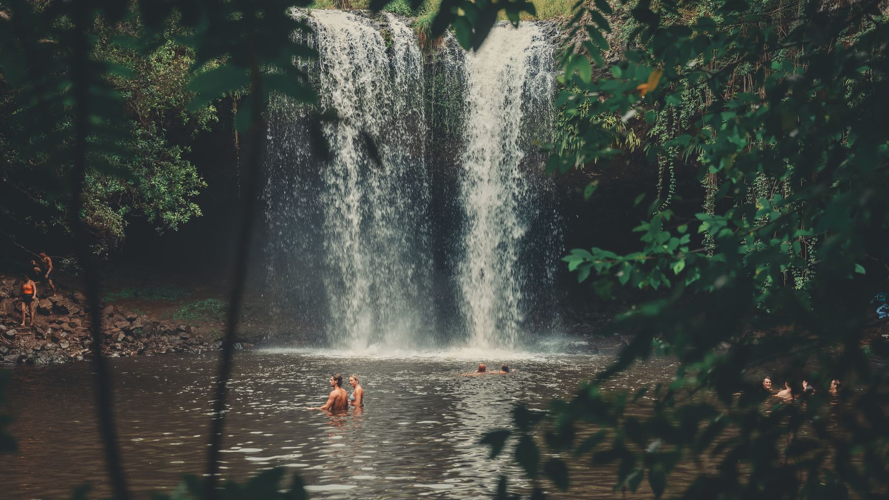
Thac Dak Lung, Quang Ngai प्रांत के पश्चिमी ऊंचे इलाकों (western highlands) में गहराई में स्थित है। यह उस सीमा क्षेत्र के पास है जो प्रशासनिक पुनर्गठन के तहत বৃহত্তর Quang Ngai में शामिल होने से पहले Kon Tum का हिस्सा हुआ करता था। यह झरना गहरे बेसाल्ट चट्टानों के कई स्तरों से होकर पुराने जंगलों से घिरे एक ठंडे कुंड में गिरता है। मध्य Vietnam (베트남 / 越南 / ベトナム) के पर्यटन सर्किट में यह कोई बहुत प्रसिद्ध जगह नहीं है — Da Nang से दक्षिण की ओर जाने वाले अधिकांश यात्री Hoi An या Quy Nhon के पक्ष में भीतरी Quang Ngai को पूरी तरह से छोड़ देते हैं। यही कारण है कि यह जगह इतनी शांत रहती है।
यह झरना लंबे समय से आसपास के गांवों में रहने वाले Hre और Co Tu जातीय अल्पसंख्यक समुदायों के लिए एक खास जगह रहा है। उनके लिए यह कोई पर्यटक आकर्षण नहीं है — यह बस उनके परिदृश्य का एक हिस्सा है, जहाँ वे गर्मी से राहत पाते हैं और पानी इकट्ठा करते हैं। यहाँ पर्यटन का बुनियादी ढांचा न के बराबर है, जो इसकी खासियत भी है और एक चुनौती भी।
यात्री यहाँ क्यों जाते हैं
जो लोग Thac Dak Lung तक पहुँचते हैं, वे अक्सर Central Highlands (중부 고원 / 中部高原 / 中部高原) के रास्तों पर यात्रा करने वाले मोटरबाइक यात्री होते हैं, या फिर वे लोग जिनकी तटीय राजमार्गों से हटकर कुछ नया देखने में सच्ची दिलचस्पी होती है। इसका आकर्षण बिल्कुल स्पष्ट है: घने जंगल के बीच एक शक्तिशाली, कई स्तरों वाला झरना, जहाँ आसपास लगभग कोई नहीं होता। यहाँ कोई टिकट बूथ नहीं है, कोई सेल्फी प्लेटफॉर्म नहीं है, और पॉप संगीत बजाने वाले कोई लाउडस्पीकर नहीं हैं।
यहाँ तक की यात्रा ही अपने आप में एक बड़ा अनुभव है। Quang Ngai शहर से पश्चिम की ओर जाने वाली सड़क धान के खेतों, छोटी Kinh और जातीय अल्पसंख्यक बस्तियों से होते हुए पहाड़ी इलाकों की ओर चढ़ती है, जहाँ काली मिर्च के बागानों की जगह घने जंगल ले लेते हैं। यदि आपने तट पर "com tam" खाते हुए और ट्रैफ़िक से बचते हुए कई दिन बिताए हैं, तो यहाँ की पहाड़ी हवा और शांति आपको एक इनाम की तरह लगेगी।
घूमने का सबसे अच्छा समय
सितंबर से दिसंबर के बीच जाने की योजना बनाएं। मध्य Vietnam के इस हिस्से में बारिश का मौसम लगभग अगस्त से नवंबर तक रहता है, और हालांकि यह अजीब लग सकता है, लेकिन झरने को प्रभावशाली दिखने के लिए हाल ही में हुई बारिश की आवश्यकता होती है। सितंबर के अंत तक, पानी की मात्रा अपने चरम पर होती है। अक्टूबर और नवंबर आदर्श महीने हैं — जंगल गहरा हरा होता है, झरने पूरे वेग से बहते हैं, और पगडंडियाँ गीली होने के बावजूद चलने लायक होती हैं।
जनवरी से अप्रैल के बीच जाने से बचें। मार्च तक, शुष्क मौसम के कारण ऊपरी जलधाराएँ सूख जाती हैं, और Thac Dak Lung सिकुड़कर एक पतली धार बन सकता है। आप घंटों की यात्रा करके केवल निराश होंगे।
बीच के महीने — मई से अगस्त — भी ठीक हो सकते हैं, लेकिन दोपहर के समय तूफान तेजी से आते हैं और झरने तक जाने वाली कच्ची सड़कें फिसलन भरी हो जाती हैं। इस दौरान सुबह जल्दी यात्रा शुरू करना बेहद जरूरी है।
Quang Ngai शहर से वहाँ कैसे पहुँचें
Quang Ngai शहर सबसे नजदीकी मुख्य केंद्र है, जो आपके द्वारा चुने गए मार्ग के आधार पर लगभग 70-80 km पूर्व में स्थित है।
मोटरबाइक द्वारा (अनुशंसित): Quang Ngai में लगभग 150,000-200,000 VND/दिन के हिसाब से एक सेमी-ऑटोमैटिक (Honda Wave या Blade) किराए पर लें। QL24 पर पश्चिम की ओर ऊंचे इलाकों की तरफ बढ़ें, फिर स्थानीय सड़कों से दक्षिण की ओर झरने वाले क्षेत्र की तरफ जाएं। एक तरफ के लिए 2.5-3 घंटे का समय मानकर चलें — आखिरी 15-20 km का रास्ता संकरा और कई जगह कच्चा है। एक फुल टैंक राउंड ट्रिप के लिए पर्याप्त है, लेकिन उचित पेट्रोल स्टेशन वाले आखिरी शहर को छोड़ने से पहले टैंक फुल करवा लें।
कार या टैक्सी द्वारा: यह संभव है लेकिन महंगा और कम व्यावहारिक है। Quang Ngai से एक निजी कार का पूरे दिन की वापसी यात्रा का किराया लगभग 1,200,000-1,500,000 VND होता है। सड़क का अंतिम हिस्सा सेडान कारों के लिए नहीं बना है — आपको अच्छे ग्राउंड क्लीयरेंस वाले वाहन की आवश्यकता होगी।
बस द्वारा: झरने तक कोई सीधी सार्वजनिक बस नहीं जाती है। आप Quang Ngai से पश्चिम की ओर Ba To जिले के लिए एक स्थानीय बस ले सकते हैं (लगभग 60,000 VND), लेकिन आपको आखिरी हिस्से के लिए अभी भी "xe om" (मोटरबाइक टैक्सी) की आवश्यकता होगी, और उसका मिलना भी तय नहीं है।

Pexels पर Thái Trường Giang द्वारा फोटो
क्या करें
बेस पूल में तैरें
सबसे निचले स्तर के नीचे का मुख्य कुंड तैरने के लिए काफी गहरा है और इतना ठंडा है कि आपकी सांसें रुक सकती हैं। किनारे के आसपास की चट्टानें काईदार और फिसलन भरी हैं — सावधानी से चलें। यहाँ कोई हैंडरेल, कोई लाइफगार्ड और कोई चेंजिंग रूम नहीं है। अपने फोन के लिए एक ड्राई बैग जरूर लाएं।
सीढ़ीदार झरनों पर ट्रेकिंग करें
Thac Dak Lung कोई एक सीधा गिरने वाला झरना नहीं है — यह लगभग 200 मीटर की ऊंचाई तक फैली झरनों की एक श्रृंखला है। जंगल के बीच से एक कच्ची पगडंडी झरने के साथ-साथ ऊपर की ओर जाती है। यह खड़ी है, बारिश के बाद कीचड़ से भर जाती है, और इस पर कोई निशान नहीं हैं। ऊपरी स्तरों का पता लगाने और वापस नीचे आने के लिए 1-1.5 घंटे का समय रखें। सही जूते पहनना बहुत जरूरी है — पहली गीली चट्टान पर ही फ्लिप-फ्लॉप (चप्पलें) आपको धोखा दे देंगी।
आस-पास के जातीय अल्पसंख्यक गांवों का दौरा करें
झरने के कुछ किलोमीटर के दायरे में कई Hre समुदाय रहते हैं। यदि आप सम्मानपूर्वक पेश आते हैं — एक मुस्कान, हाथ हिलाना, या शायद कुछ फल या स्थानीय उपज खरीदना — तो लोग आमतौर पर स्वागत करते हैं। बिना पूछे किसी के घर में न घुसें या लोगों की तस्वीरें न लें। Vietnamese के कुछ शब्द बहुत काम आते हैं; यहाँ अंग्रेजी का अस्तित्व लगभग न के बराबर है।
भोर में पक्षी दर्शन (Birdwatching)
झरने के आसपास का जंगल पक्षियों की आश्चर्यजनक प्रजातियों का घर है। गर्मी बढ़ने से पहले सुबह का समय इसके लिए सबसे अच्छा होता है। आपको किसी विशेष उपकरण की आवश्यकता नहीं होगी — बस दूरबीन और धैर्य चाहिए। पेड़ों की छतरी (canopy) घनी है, इसलिए देखने से ज्यादा सुनने पर ध्यान दें।
पिकनिक मनाएं और कुछ न करें
खाना लाएं, एक समतल चट्टान खोजें, और बैठ जाएं। गिरते पानी की आवाज़ और शून्य फोन सिग्नल का अनुभव ही अपने आप में एक बेहतरीन गतिविधि है।
आस-पास कहाँ खाएं
झरने के पास रेस्तरां की उम्मीद न करें। निकलने से पहले Quang Ngai से अपना लंच पैक कर लें — स्ट्रीट कार्ट से "banh mi" और पानी की कुछ बोतलें पर्याप्त होंगी।
Ba To जिला शहर (झरने से पहले की आखिरी उचित बस्ती) में, स्थानीय com binh dan (रोजमर्रा की चावल की प्लेट) की दुकानों की तलाश करें जो 30,000-50,000 VND में साधारण भोजन परोसती हैं। यदि आपको मेनू में "banh xeo" दिखाई दे, तो उसे जरूर ऑर्डर करें — यहाँ के मध्य Vietnamese संस्करण में झींगा और सूअर के मांस के साथ हल्दी वाले घोल का उपयोग किया जाता है, जिसे साग में लपेटा जाता है। यह Saigon (사이공 / 西贡 / サイゴン) शैली से छोटा होता है और इसे आज़माना तो बनता है।
Quang Ngai शहर वापस आकर, "mi quang (미꽝 / 广南面 / ミークアン)" की तलाश करें — यह प्रांत का एक खास नूडल व्यंजन है, जिसमें हल्दी वाला शोरबा (broth), झींगा, सूअर का मांस, जड़ी-बूटियाँ और राइस क्रैकर्स होते हैं। सेंट्रल मार्केट के पास Don Quang Ngai लगभग 35,000 VND में एक बढ़िया बाउल परोसता है।
कहाँ ठहरें
Thac Dak Lung में ठहरने की कोई व्यवस्था नहीं है। आपके विकल्प इस प्रकार हैं:
- Ba To शहर: 200,000-350,000 VND की रेंज में कुछ बुनियादी गेस्टहाउस ("nha nghi") हैं। ये काफी साफ-सुथरे होते हैं, ठंडे पानी, पंखे या बेसिक एसी की सुविधा होती है। अंग्रेजी बोलने वाले कर्मचारियों की उम्मीद न करें।
- Quang Ngai शहर: यहाँ अधिक विकल्प मौजूद हैं। Quang Trung सड़क के आसपास बजट होटल 250,000 VND/रात से शुरू होते हैं। गर्म पानी और अच्छे वाईफाई वाले मिड-रेंज विकल्प 400,000-700,000 VND तक आते हैं। यहाँ कुछ भी लक्जरी नहीं है — यह Hoi An (호이안 / 会安 / ホイアン) नहीं है।
- झरने के पास होमस्टे: कभी-कभी, स्थानीय लोग रात भर रुकने के लिए बुनियादी सुविधाएं देते हैं। यह अनौपचारिक और अप्रत्याशित है — निकटतम गांव में पूछताछ करें, लेकिन पूरी तरह से इस पर निर्भर न रहें।
Pexels पर Brayden Stanford द्वारा फोटो
व्यावहारिक सुझाव जो स्थानीय लोग आपको देंगे
- नकद (Cash) साथ रखें। Ba To के बाद कोई एटीएम नहीं है, और कोई भी कार्ड स्वीकार नहीं करता है।
- जल्दी शुरुआत करें। दोपहर की गर्मी और बारिश से बचने के लिए सुबह 6:00-6:30 बजे तक Quang Ngai से निकल जाएं।
- लंबी पतलून और बंद जूते पहनें। बारिश के मौसम में जंगल में जोंक (leeches) आम हैं। अपनी पतलून को मोजे के अंदर खोंस लें — यह देखने में अजीब लगता है लेकिन काम करता है।
- एक बेसिक फर्स्ट-एड किट साथ रखें। निकटतम क्लिनिक Ba To में है, जो एक घंटे से अधिक की दूरी पर है।
- Ba To छोड़ने से पहले अपना फ्यूल टैंक फुल कर लें। आखिरी रास्ते पर कोई पेट्रोल स्टेशन नहीं है।
बचने योग्य सामान्य गलतियाँ
- शुष्क मौसम में जाना और झरने की उम्मीद करना। यात्रा तय करने से पहले हाल ही में हुई बारिश की जांच कर लें। मार्च और अप्रैल लगभग हमेशा निराश करते हैं।
- पगडंडी पर फ्लिप-फ्लॉप पहनना। आप फिसलेंगे ही। इसमें कोई शक नहीं है।
- पर्याप्त पानी न लाना। प्रति व्यक्ति कम से कम दो लीटर पानी रखें। जंगल में उमस बहुत ज्यादा होती है।
- इसे आधे दिन की यात्रा मानकर जल्दबाजी करना। यहाँ की सड़कें धीमी हैं। Quang Ngai से पूरे दिन की योजना बनाएं, या इससे भी बेहतर, रात भर Ba To में रुकें और सुबह तरोताजा होकर झरने पर जाएं।
- कचरा छोड़ना। यहाँ सफाई करने वाला कोई दल नहीं है। आप जो कुछ भी साथ लाएं, उसे वापस ले जाएं। यह कहने की जरूरत नहीं होनी चाहिए, लेकिन कभी-कभार किसी शाखा पर फंसी प्लास्टिक की थैली कुछ और ही कहानी बयां करती है।
व्यावहारिक नोट्स
Thac Dak Lung आपके प्रयासों का फल देता है। यह कोई छोटा सा चक्कर नहीं है — यह मध्य Vietnam के उस हिस्से से होकर जाने वाली कच्ची सड़कों पर पूरे दिन का कमिटमेंट है जिसे अधिकांश यात्री छोड़ देते हैं। यदि आप पहले से ही Quang Ngai घूम रहे हैं या तट और Central Highlands के बीच यात्रा कर रहे हैं, तो पश्चिम की ओर जाने के लिए यह सबसे अच्छे कारणों में से एक है। बस बारिश के हिसाब से अपनी योजना बनाएं, समझदारी से पैकिंग करें, और अपनी उम्मीदों को इंस्टाग्राम के बजाय वास्तविकता पर आधारित रखें।
अंतिम अपडेट · May 29, 2026 · स्वतंत्र शोध, कभी प्रायोजित नहीं।





