Lung Cu Flag Tower sits at 1,500 metres above sea level, marking Vietnam (베트남 / 越南 / ベトナム)'s northernmost geographic point. The site is in Ha Giang province, in the far north of the Dong Van Karst Plateau. Most visitors come as a side trip from Dong Van, 20 km to the south, or slot it into the wider Ma Pi Leng loop.
The drive from Dong Van
From Dong Van town, take the road north towards Meo Vac. After about 15 km, you'll see a signed turnoff to the right (east) towards Lung Cu. The final 5 km climbs steeply through pine forest and past scattered Hmong farmhouses. The road is paved but narrow; in wet season (May–October), landslide warnings appear. Most tourists hire a motorbike driver in Dong Van (around 300,000–400,000 VND for a round trip with waiting time) or rent their own (200,000 VND per day for a manual bike). If you're self-driving a car, confirm road conditions at your Dong Van hotel first—not all roads are passable year-round.
The drive itself is one of the better stretches of road in the province. You'll pass through Lo Lo Chai village about 3 km before the tower—worth a slow roll-through even if you don't stop. The Lo Lo are a different ethnic group from the Hmong, and their houses have distinctive clay walls painted with geometric motifs. On weekday mornings, the road is almost empty. Weekends and holidays are a different story: tour buses from Dong Van create bottlenecks on the single-lane sections, and the parking area fills by 10 a.m.
The flag tower and the climb
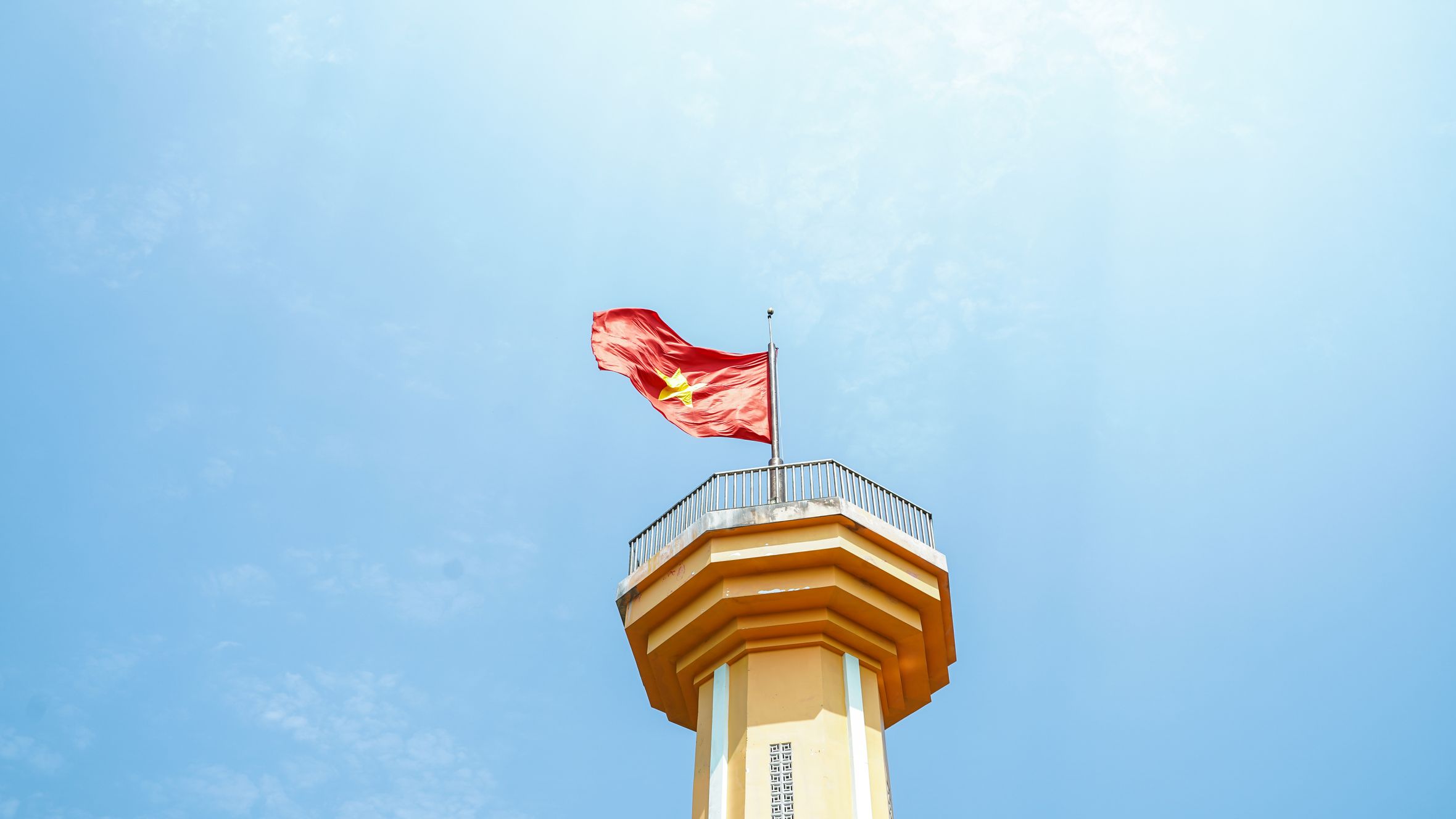
You'll arrive at a small parking area and souvenir stalls. The actual tower is another 500 metres uphill on foot. The path is steep, concrete-stepped in places, and can be slippery in rain. Most people take 15–20 minutes to reach it. The tower itself is a white concrete structure, about 15 metres tall, with a Vietnamese flag flying from the top. It's modest, not dramatic—but the altitude and the fact that you're standing at Vietnam's northernmost extremity give it weight.
From the tower, you can see into Yunnan province across the border. The landscape rolls away in green ridges and valleys. On clear days (most common October–April), the view stretches 20–30 km. The Chinese side looks very similar: limestone karst, small villages, forested slopes. There's a border checkpoint below the tower, but tourists don't cross.
At the base of the steps you'll find a ticket booth charging 20,000 VND per person (as of late 2024). A few vendors sell bottled water (10,000 VND), instant noodles, and roasted corn. Don't expect much variety—this isn't a food street. If you want a proper meal, eat before you leave Dong Van. "Pho" shops and "banh mi" carts cluster around Dong Van's central market, and a full bowl of "pho" runs 35,000–50,000 VND there.
Hmong settlements nearby
The villages around Lung Cu are predominantly "Hmong Trang" (white Hmong), identifiable by the women's white headscarves and embroidered hemp jackets. Several hamlets lie within walking distance—Khau Vai and Khau Phong are the most visited. You can hire a guide in Dong Van or organize a homestay night for 200,000–300,000 VND (usually includes dinner, breakfast, and a family tour). The houses are timber-frame, thatched or corrugated-iron roofed, built on stilts. Women still weave and embroider by hand. There's no tourism infrastructure here—no restaurants, no shops—so bring cash and manage expectations. You're not visiting a cultural show; you're passing through a working agricultural community.
Homestay dinners typically include "thang co"—a Hmong hotpot of offal and herbs that's an acquired taste but worth trying once. If that's not for you, most families will prepare a simpler meal of rice, greens, and pork. "Ruou ngo" (corn wine) will almost certainly appear. Refusing a small glass is considered impolite, but nobody will pressure you past one or two. These villages have limited phone signal and no ATMs, so carry enough cash for the entire visit.

Photo by Vietnam Hidden Light on Pexels
Best time to visit
October to November is ideal: cool, dry, and clear skies. December to February is also good but can be foggy. March and April are warm and clear. May to September brings daily rain, mist, and poor visibility; the road becomes treacherous. Winter (January–February) can see light snow at the summit, but this is rare. Avoid the Tet holiday (late January/early February), when every road in Ha Giang clogs with domestic visitors.
If you time it right, early October also overlaps with the buckwheat flower season. The hillsides around Dong Van and Lung Cu turn pale pink and white with "tam giac mach" (buckwheat) blossoms—a big draw for domestic photographers. The annual Buckwheat Flower Festival usually falls in late October or November, centered in Dong Van town. Expect higher guesthouse prices (400,000–600,000 VND per night vs. 200,000–350,000 VND in low season) and busier roads during the festival week.
Combining with the Ma Pi Leng loop
Most visitors don't drive to Lung Cu in isolation. The town sits on the western edge of the broader Ha Giang loop, a 350 km motorcycle circuit that includes Meo Vac, Yen Minh, and the dramatic Ma Pi Leng Pass. If you're already in Dong Van (usually the base for the loop), you can add Lung Cu as a half-day detour. A full loop takes 2–4 days depending on stops and pace. Stay overnight in Dong Van, do Lung Cu and a Hmong village one day, then continue east towards Meo Vac and the Ma Pi Leng Pass the next.

Photo by Du Tử Mộng on Pexels
What it means to Vietnamese
The tower is more than a viewpoint. For many Vietnamese tourists, especially from the south, visiting Lung Cu is a patriotic pilgrimage, a way to "touch" the nation's boundary. You'll see school groups, military personnel, and families posing with the flag. The site features in school history textbooks. For Hmong locals, it's a landmark and a source of seasonal work (guides, homestay income, souvenir sales), though the economic benefit remains modest.
Getting to Dong Van from Hanoi
Bring water and snacks; there are no facilities at the tower itself. Temperatures drop sharply at altitude—bring a fleece even in warm season. Guides are helpful if you want to visit Hmong villages, but not essential for the flag tower itself. Most people spend 2–3 hours at the site (drive, walk, views, return). If you're arriving from Hanoi, expect 8–10 hours of travel to reach Dong Van; fly to Hanoi first, then take a bus or rent a driver for the journey north.
The most common route from Hanoi is the overnight sleeper bus to Ha Giang city (departing around 9 p.m. from My Dinh bus station, arriving around 5 a.m., roughly 180,000–250,000 VND). From Ha Giang city, local buses run to Dong Van (about 4 hours, 100,000 VND) or you can arrange a private car for around 1,500,000 VND. Some travelers hire a motorbike and "easy rider" guide directly from Ha Giang city to cover the entire loop, including the Lung Cu detour—expect to pay 800,000–1,200,000 VND per day for a driver-guide including fuel.
What to eat in Dong Van before or after the trip
Dong Van town is small, but it has enough food options to keep you fed between mountain days. The old-quarter market area, near Dong Van Old Quarter's stone houses, is the center of activity. For breakfast, look for "banh cuon (반꾸온 / 蒸米卷 / バインクオン)"—thin steamed rice rolls filled with minced pork and mushroom—sold from street-side steamers for 20,000–30,000 VND. Several shops along the main road serve "bun" (rice noodle soup) with pork or chicken for 35,000–45,000 VND.
For something more substantial, a handful of local restaurants serve "com tam" (broken rice plates) and stir-fried dishes for 40,000–60,000 VND. "Thang co" appears at market stalls, particularly on Sunday mornings when the weekly Dong Van market draws Hmong, Lo Lo, and Tay communities from surrounding villages. That Sunday market, by the way, is worth structuring your itinerary around—it's one of the most genuine weekly ethnic markets left in the north.
Coffee in Dong Van is basic but functional. Don't expect Hanoi's "ca phe trung" (egg coffee) scene. Most cafes serve "ca phe sua da"—strong drip coffee with condensed milk over ice—for 15,000–25,000 VND. A few newer guesthouses have espresso machines, but the local drip style is better suited to the setting. After a morning at Lung Cu in the cold, a hot "ca phe den" (black coffee) at a market stall is one of those small comforts that stays with you.
Common mistakes visitors make
Underestimating the cold. Ha Giang sits at altitude and the weather shifts fast. Even in April, mornings at Lung Cu can dip to 10°C. Travelers who pack only for tropical Vietnam end up buying cheap fleece jackets at Dong Van market—functional, but you'll wish you'd brought your own.
Rushing the visit. A lot of tour groups treat Lung Cu as a photo stop: bus in, climb, snap the flag, bus out in 90 minutes. You miss the surrounding villages and the quieter trails that way. Budget a full half-day, minimum.
No cash. There is one ATM in Dong Van town (Agribank, near the post office), and it runs out of cash on busy weekends. Withdraw what you need in Ha Giang city. Everything around Lung Cu—homestays, guides, meals, motorbike hire—is cash only. Mobile payment apps like MoMo are useless here.
Visiting on a public holiday. Vietnamese long weekends / 越南春节 / テト)) flood the Ha Giang loop with domestic traffic. Roads that feel meditative on a Tuesday become frustrating convoys. If your dates are flexible, go midweek.
Expecting a polished tourist site. Lung Cu is not the Temple of Literature or Imperial Citadel in Hue. There's no museum, no audio guide, no curated experience. That's the point. The reward is the landscape and the remoteness, not the infrastructure.
Quick reference
- Location: Lung Cu commune, Dong Van district, Ha Giang province
- Altitude: approximately 1,500 m
- Distance from Dong Van: 20 km (about 40 minutes by motorbike)
- Distance from Ha Giang city: 150 km (about 4 hours by motorbike or car)
- Distance from Hanoi: roughly 470 km (8–10 hours by bus + local transport)
- Entry fee: 20,000 VND per person
- Climb to tower: 500 m uphill, 15–20 minutes
- Time needed at site: 2–3 hours including drive from Dong Van
- Best months: October–April (dry, clear)
- Worst months: June–August (rain, fog, landslide risk)
- Motorbike hire in Dong Van: 200,000 VND/day (manual), 250,000–300,000 VND/day (semi-auto)
- Round-trip driver from Dong Van: 300,000–400,000 VND
- Nearest ATM: Agribank, Dong Van town center
- Mobile signal: weak to none at the tower and surrounding villages
Final note
Lung Cu is not the kind of place that overwhelms you in the moment. It's quiet, exposed, and a little anticlimactic if you're expecting a monument. But the drive there—through some of the most rugged terrain in northern Vietnam—and the knowledge of where you're standing tend to settle in later. For most people who ride the Ha Giang loop, this is the point on the map that sticks.
Last updated · May 29, 2026 · independently researched, never sponsored.