Pu Ta Leng sits at 3,049 meters in Lai Chau province, making it Vietnam (베트남 / 越南 / ベトナム)'s third-highest peak after Fansipan and Pu Si Lung. Unlike Fansipan — which now has a cable car and a crowd problem — Pu Ta Leng has no infrastructure at the top, no ticket booth, and no easy way up. That's the point.
What Pu Ta Leng is and why people trek it
Pu Ta Leng rises above the Ta Leng commune in Tam Duong district, roughly 35 km northwest of Lai Chau city. The peak only gained traction with Vietnamese trekking groups around 2012-2013, and it remains far less trafficked than Sapa or Fansipan. The standard route is a two-day, one-night trek covering about 30 km round trip through dense forest, bamboo groves, and exposed ridgeline. Elevation gain from the trailhead is around 2,000 meters.
People come here because it's a proper mountain. No steps, no handrails, no selfie platforms. The trek demands fitness, decent gear, and a local guide — it's not a day hike you can wing. If you've already done Fansipan and want something rawer without leaving the northwest, Pu Ta Leng is the logical next step.
Best time to visit
The clearest windows are October through December and March through April. October and November tend to offer the best visibility — cold, dry air and a reasonable chance of seeing the summit panorama without cloud cover.
Avoid June through August entirely. The monsoon turns the trail into a mud chute, leeches come out in force, and cloud cover sits at the summit for days straight. January and February can be bitterly cold at altitude — temperatures near the peak drop below freezing at night, and occasional frost or even light snow hits above 2,800m. Possible if you have proper cold-weather gear, but not comfortable.
How to get there
The gateway is Lai Chau city (the current provincial capital, not the old Lai Chau town now called Tam Duong).
From Hanoi: The most common route is a sleeper bus from My Dinh bus station to Lai Chau city — roughly 10-11 hours, departing in the evening, arriving early morning. Tickets run 350,000-450,000 VND. Several operators cover this route; Hai Van and Hung Thanh are reliable names.
Alternatively, you can ride to Sapa (사파 / 沙坝 / サパ) first (6-7 hours by bus, or the train to Lao Cai then a van up), then take a local bus or hire a car from Sapa to Lai Chau city — about 100 km, roughly 3 hours on mountain roads. This makes sense if you're already in Sapa.
From Lai Chau city to the trailhead: The starting point is in or near Ta Leng commune, Tam Duong district — about 35 km from Lai Chau city. Your trekking operator will arrange a van or motorbike transfer to the trailhead. This leg takes about 1-1.5 hours depending on road conditions.

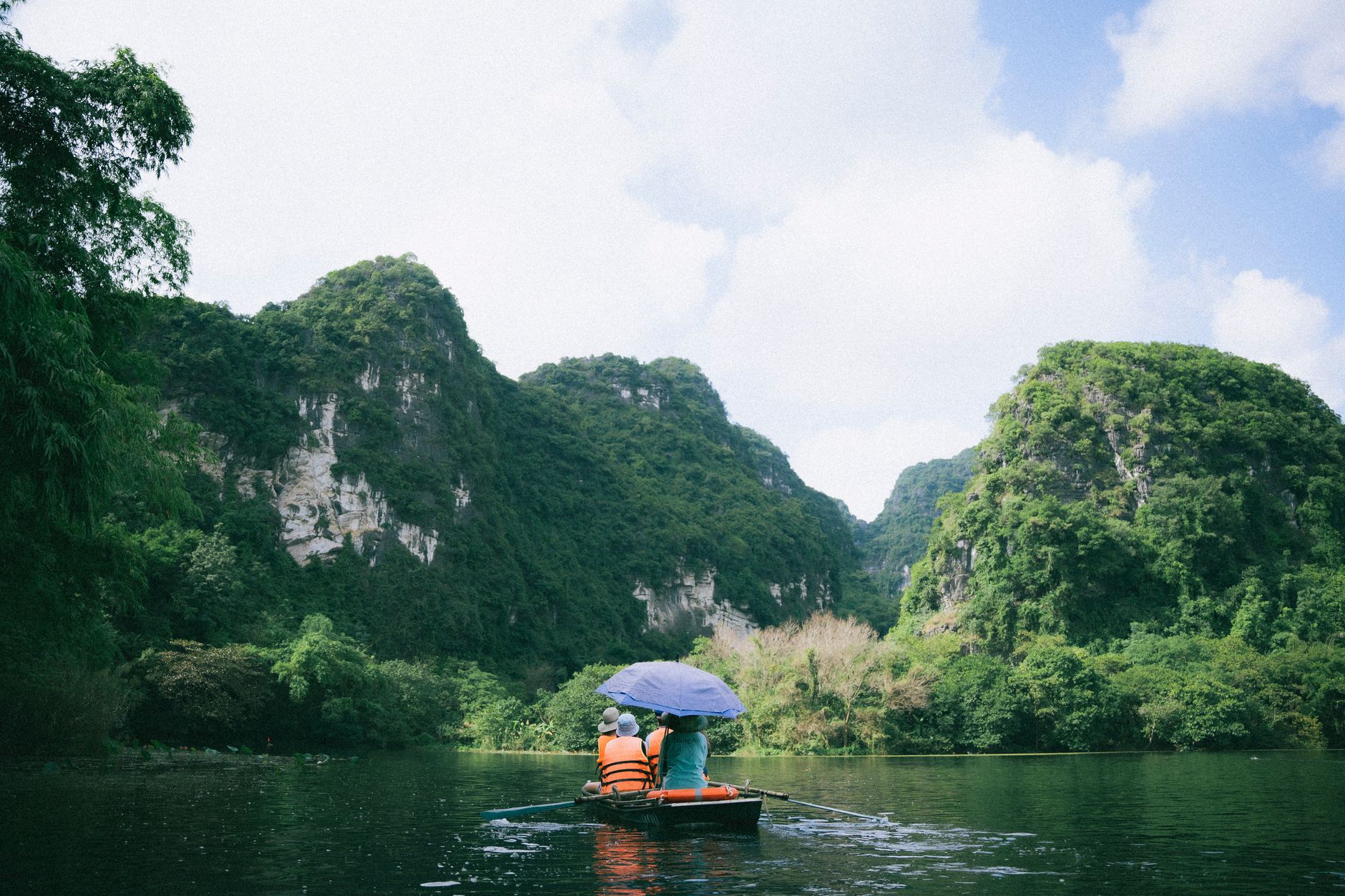
Photo by Vietnam Hidden Light on Pexels
What to expect on the trek
Day 1 — Forest and camp
The first day covers roughly 12-15 km from the trailhead to a campsite at around 2,400-2,600m elevation. The trail passes through Dao and Hmong villages near the base, then enters dense subtropical forest. Expect steep, rooty terrain and stream crossings. The camp is a flat clearing in the forest — your guide team sets up tents and cooks dinner over a fire. No guesthouses, no shelters.
Day 2 — Summit push and descent
You start early, often around 4-5 AM, to reach the summit before clouds roll in. The final push above the treeline is exposed and steep — hands-on-rock scrambling in a few sections. On a clear morning, the view stretches across the Hoang Lien Son range toward Fansipan and deep into the valleys of Lai Chau. The descent back to the trailhead takes most of the remaining day. Total day two: 8-10 hours of walking.
Other things worth doing in the area
- Tam Duong market — A local market town between Lai Chau city and the trailhead. If your trek starts on a Sunday, the weekend market draws Dao, Hmong, and Lu minorities from surrounding villages. Worth an hour before or after the trek.
- Sin Suoi Ho village — A Hmong village about 25 km from Lai Chau city, known for its plum blossoms in January-February and cardamom fields. A half-day visit pairs well with a pre-trek or post-trek day.
- Hot springs near Phong Tho — About 40 km northwest of Lai Chau city, a decent reward for wrecked legs after the descent.
Where to eat nearby
Lai Chau city isn't a food destination, but you'll eat well enough. Look for "pho" stalls near the central market for breakfast — the local beef pho here uses tougher, leaner cuts than Hanoi-style bowls, served with a heap of fresh herbs.
Seek out "thang co" — a Hmong offal hotpot made from horse or buffalo organs, slow-cooked with cardamom, ginger, and local herbs. It's an acquired taste and an acquired texture, but it's the signature dish of the northwest highlands. You'll find it at market stalls in Tam Duong or at small eateries on the road between Lai Chau city and the trailhead. A bowl runs 30,000-50,000 VND.
Where to stay
In Lai Chau city, budget guesthouses ("nha nghi") go for 150,000-250,000 VND per night. Clean enough, hot water, Wi-Fi. Lan Anh and Phuong Thanh are names that come up often. A step up gets you a proper hotel room for 400,000-600,000 VND — try places along the main road near the bus station.
On the mountain itself, it's tents only. Your trekking operator provides camping gear as part of the package. Most two-day packages from Lai Chau-based operators run 2,500,000-4,000,000 VND per person, including guide, porter, meals, camping equipment, and transport to the trailhead. Group size affects the price — smaller group, higher per-person cost.

Photo by Lucas Tran on Pexels
Practical tips
- You need a guide. This is not optional. The trail is unmarked in sections, weather changes fast, and the local commune requires trekkers to go with a registered guide. Book through operators in Lai Chau city or Sapa — avoid Hanoi middlemen who subcontract everything and add markup.
- Pack for cold. Even in October, nights at camp hover around 5-8°C. Bring a proper sleeping bag or confirm your operator provides one rated for near-freezing temps. A down jacket and thermal base layer are non-negotiable.
- Bring trekking poles. The descent is steep and long. Your knees will thank you.
- Leeches are real from May to September. Leech socks or high gaiters help. Tobacco water on your boots is the local trick.
- Cash only. There are no ATMs on the mountain and limited ones in Tam Duong. Withdraw what you need in Lai Chau city before heading out.
Common mistakes
- Underestimating the difficulty. Pu Ta Leng is harder than the Fansipan trek (the walking route, not the cable car). If your fitness level is "occasional weekend hike," train for a few weeks before going.
- Booking the cheapest operator. The difference between a 2,500,000 VND package and a 3,500,000 VND one is often better food, warmer sleeping bags, and a guide who actually knows the upper trail in fog. Ask what gear is included before you book.
- Skipping the weather check. If your guide says conditions are bad and suggests postponing, listen. The summit ridge in high wind or zero visibility isn't a place to push through on principle.
Practical notes
Pu Ta Leng rewards preparation. It's a real mountain trek in a province that most travelers skip entirely on their way between Hanoi and Sapa. Give yourself at least three days total — one to arrive in Lai Chau city and sort logistics, two for the trek — and you'll come back with something better than a cable car selfie.
Last updated · May 29, 2026 · independently researched, never sponsored.