The Dong Van Karst Plateau sits at Vietnam (베트남 / 越南 / ベトナム)'s northernmost reach, a place where limestone towers jut from narrow valleys and single-track roads carved into cliff faces connect small Hmong, Tay, and Lo Lo settlements. It's one of the few UNESCO Global Geoparks in Southeast Asia, and it earns that status honestly — the geology here is roughly 400-600 million years old, visible in exposed rock faces you'll pass constantly on the road.
What it is and why it matters
The plateau covers four districts — Dong Van, Meo Vac, Yen Minh, and Quan Ba — in what was formerly Ha Giang province. Following the 2025 administrative merger, this area now falls under Tuyen Quang province, though locals and travelers still refer to it as the Ha Giang loop region. Nothing on the ground has changed: same roads, same towns, same border checkpoints.
The karst landscape here isn't decorative background. It defines daily life — farmers grow corn in shallow pockets of soil between rock, and water scarcity shapes everything from architecture to market schedules. The plateau was recognized as a UNESCO Global Geopark in 2010.
Why travelers go
The Ha Giang (하장 / 河江 / ハーザン) loop, a roughly 350 km circuit that passes through the plateau, is widely considered the best motorbike route in Vietnam. That reputation is deserved. The road between Meo Vac and Dong Van, especially the stretch through Ma Pi Leng Pass, follows a cliff edge above the Nho Que River with drops that make your hands tighten on the handlebars. Beyond the road itself, it's one of the few parts of northern Vietnam where ethnic minority culture hasn't been fully packaged for tourism — Sunday markets in Dong Van and Meo Vac still function as actual trading posts, not souvenir bazaars.
Best time to visit
September to November is the sweet spot. Rice terraces in the lower elevations around Quan Ba are golden in late September and early October. Skies are mostly clear, and temperatures sit between 15-25°C during the day.
March to May works too — buckwheat flowers bloom across the plateau in late October into November (a separate draw), and spring brings wildflowers and warmer days, though fog can close in.
December to February is cold. Genuinely cold. Temperatures drop below 5°C at night in Dong Van town, and frost isn't unusual. Roads can be slick. If you ride in winter, pack proper layers — not the thin rental jackets sold in Hanoi.
June to August means rain, landslides, and reduced visibility. Rideable, but you'll spend time waiting for roads to reopen.
How to get there
Most travelers base out of Ha Giang city (now administratively part of Tuyen Quang province), which remains the natural gateway.
- From Hanoi: Sleeper buses run nightly, departing around 8-9 PM and arriving around 4-5 AM. Companies like Hung Thanh and Cau Me operate this route. Expect to pay 250,000-350,000 VND one way. The ride is roughly 300 km and takes 6-7 hours.
- From Sapa: Less common but doable. Local buses or private transfers run via Lao Cai, taking 7-8 hours with a connection. Not the most comfortable route.
From Ha Giang city, the loop itself starts heading north toward Quan Ba (about 45 km). Most people rent motorbikes in Ha Giang city — a Honda XR150 goes for around 200,000-300,000 VND/day, a semi-automatic Wave for 150,000-180,000 VND/day. If you don't ride, hire an "easy rider" guide-driver for 500,000-700,000 VND/day including the bike.

Photo by HONG SON on Pexels
What to do
Ride Ma Pi Leng Pass
The 20 km stretch between Dong Van and Meo Vac is the headline. The road clings to the mountainside above the Nho Que River gorge — a vertical drop of several hundred meters with no guardrails in places. Go slow. Stop often. The viewpoint at the top has a parking area and a few drink stalls.
Walk around Dong Van Old Quarter
A compact cluster of Hmong and Chinese-influenced stone and wood houses, some over a century old. The Vuong family mansion (Dinh Vuong), about 15 km outside town in Sa Phin, is a well-preserved Hmong king's residence built in 1902 — entry is 20,000 VND and worth the detour.
Visit the Sunday markets
Dong Van's Sunday market runs early morning. Meo Vac also has a Sunday market that's less visited and more local. Arrive before 8 AM for the real activity — livestock trading, local liquor, fabric. By 10 AM, things wind down.
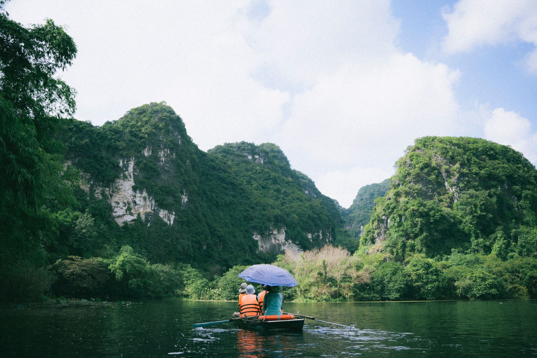
Hike to Tu San Canyon
Reachable by boat on the Nho Que River (departing from a dock near Ma Pi Leng — boat trips run about 150,000-200,000 VND per person). The canyon walls are narrow and tall. It's a short trip but worth it if the water level allows.
Lung Cu Flag Tower
Vietnam's northernmost point, marked by a flag tower on a hilltop. The 360-degree view from the top covers terraced fields and the border. About 25 km north of Dong Van town on a paved road.
Where to eat
Food on the plateau is simple and hearty. Look for "thang co" — a Hmong hot pot made from horse meat and organs, simmered with cardamom and lemongrass. It's served at most local restaurants in Dong Van and Meo Vac and costs around 40,000-60,000 VND per bowl. "Men men," a steamed corn flour dish eaten by Hmong families as a rice substitute, shows up at some local eateries and homestays.
For something more familiar, "pho" and "bun" soups are available in every town — 30,000-40,000 VND a bowl. Vietnamese coffee is widely available, though don't expect Hanoi-level egg coffee up here.
Where to stay
- Budget homestays: 100,000-200,000 VND/night. Basic rooms, shared bathrooms, often with dinner and breakfast included. Common in Dong Van, Meo Vac, Du Gia, and Quan Ba.
- Mid-range guesthouses: 300,000-600,000 VND/night. Private rooms with hot water and Wi-Fi. Dong Van town has the most options.
- Higher-end homestays/boutique lodges: 800,000-1,500,000 VND/night. A few have opened near Quan Ba and along the loop — better beds, mountain views, restaurant on-site.
Book ahead on weekends from September to November. Outside peak season, walk-ins are fine.

Photo by Nguyen Khuong on Pexels
Practical tips locals would tell you
- Fuel up in every town. Gas stations are spaced far apart. Dong Van, Meo Vac, Yen Minh, and Quan Ba all have stations, but between them you might ride 50-60 km with nothing.
- Carry cash. ATMs exist in Ha Giang city and Dong Van town, but they're unreliable. Card payments are essentially nonexistent on the plateau.
- Permits: Foreign travelers technically need a border-area permit for parts of the loop near the Chinese border (Lung Cu area). Hotels and hostels in Ha Giang city can arrange this — it's free and takes about 30 minutes. Don't skip it; checkpoints do exist.
- Road conditions change fast. A clear morning can turn into fog and rain by noon. Rockfalls happen. Ride defensively and don't push to cover too many kilometers in a day.
Common mistakes to avoid
- Trying to do the full loop in two days. Three days is the minimum to enjoy it. Four is better. Rushing means you'll skip stops and ride fatigued on dangerous roads.
- Renting the cheapest bike available. A broken-down semi-automatic on a mountain pass is not where you want to learn about vehicle maintenance. Spend the extra 50,000 VND/day for a manual bike in good condition.
- Skipping the southern section. Many riders go Quan Ba → Yen Minh → Dong Van → Meo Vac and turn back. The southern return through Du Gia is quieter, less trafficked, and arguably more scenic.
Practical notes
The Dong Van Karst Plateau rewards patience. Give it enough days, ride at your own speed, and stop when something catches your eye — a market, a valley, a roadside corn-wine stall. The loop is best experienced without a rigid schedule.
Last updated · May 29, 2026 · independently researched, never sponsored.